
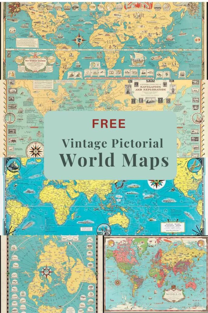
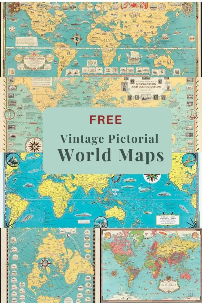
Ernest Dudley Chase was well known for his wonderfully detailed pictorial maps. I have already featured a couple of Chase maps, but here I just focus on his world pictorial maps.
You can find his charming fictitious “Map of Loveland” in the maps of love collection. Also in the old maps of Japan, there is another one of his pictorial maps.
Who Was Ernest Dudley Chase
Ernest Dudley Chase (1878-1966) was an American graphic artist from Winchester Massachusetts. He started his graphic career building his own prolific greeting card company in 1908, which he sold in 1920 to Rust Craft Publishers.
Later in life at 49 years old Chase started drawing his famous pictorial maps, which he published himself. He produced over 50 pictorial maps from the 1930s to the 1960s. Many were world pictorial maps and can be found at the famous Norman B. Leventhal Map collection at the Boston Public Library.
His detailed pictorial maps covered a broad range of places, from his home town to large world maps. These maps illustrate architectural and geographical features, historical and current events, and technological advances. They are fascinating to study and often come with explanatory notes.
Ernest Dudley Chase drew his pictorial world map using the “Mercator Projection” (1568). To celebrate this he even has an illustration Gerardus Mercator, Flemish mathematician and geographer, from the Belgian stamp of 1941-42 on his World of Stamps Map.
The Mercator Projection is the standard map projection for navigation, representing north as up and south as down everywhere while preserving local directions and shapes. It does have a slight disadvantage as it distorts the true size of some landmasses.
How To Print And Download The Worl Pictorial Maps
To download the Chase world pictorial map you want, click on the title above that map. A higher resolution image of that map will open as a new window in your browser. Then click with your mouse on that image, you will have the option to save the image to your device.
The pictorial map can then be printed at home, or uploaded to an on-line printing service. Some of these maps are quite large so may take a little while to download.
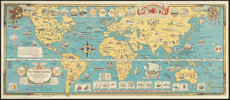
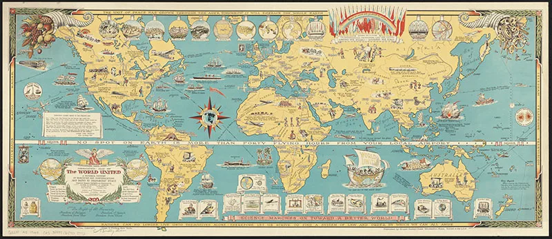
1. Chase Mercator Map of The world United
“Mercator map of the world united – a pictorial history of transport and communications and paths to permanent peace.” Published in 1944 and over a meter long.
The notes on the map describe it as a map of the world united against the awful waste of war. This is very apt, as it was published during the second world war.
Chase describes how the map illustrates peace from the days of the caveman who sought protection for his family to the present day, where nations are bound together as a family for safety.
The map is a pictorial record of technological advancement that has shrunk the world with communications and transport speed. Across the center of the map, Chase has written, “No spot on Earth is more than forty flying hours from your local airport”
In the notes, he quotes, “if as Confucius has said,” One picture is effective as a thousand words” then this map is indeed a lucid and convincing proof we can make our world a World Partnership, where all humanity is bound together for the common good”.
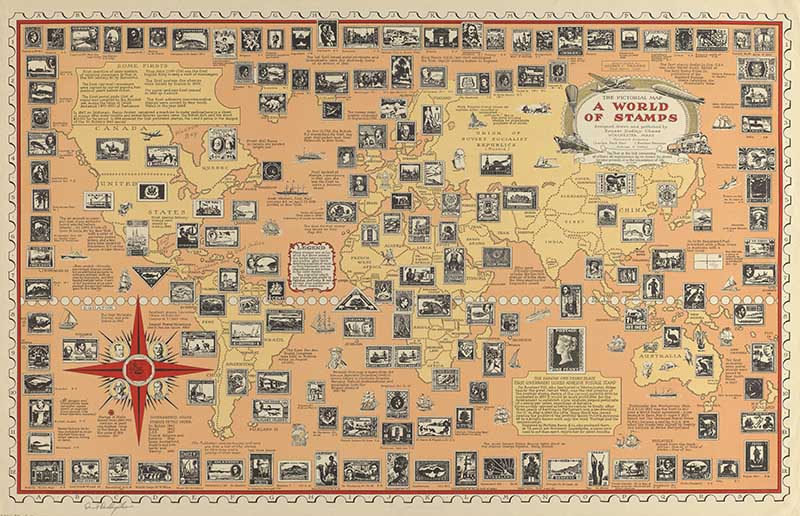
2. The Pictorial Map – A World of Stamps
This pictorial map of Chase’s illustrates the “History of Stamps. Many examples of stamps are featured in their country of origin. Others are around the edge of a map with a key corresponding to their geographical origins.
There are also many pictorial illustrations of significant landmarks and descriptive notes about the evolution of the postal delivery system.
This map includes descriptions of “Some Firsts” in mail history, such as the story of “The Famous One-Penny Black.” Even the compass rose on the map has four portraits taken from stamps: “Pasteur-Europe,” “Stanley-Africa,” “Washington – North America” and “Bolivar-South America”. They all surround a picture of the “World’s Rarest Stamp”, a British Guiana one-cent magenta.
The cartouche is decorated with different modes of transportation for delivering mail. I love the stamp like perforated boarder on the map.
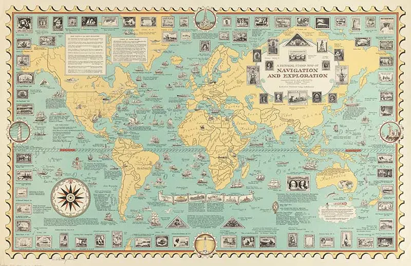
3. A Pictorial Stamp Map of Navigation and Exploration
Another fascinating vintage pictorial world map by Ernest Dudley Chase from 1951. The map features a stamp motif to illustrate navigation and exploration of the world.
The map is adorned with detailed illustrations of historically significant sea vessels. Postage stamps of ships, explorers, and discoveries frame the map.
It includes several descriptive keys and legends. One of which includes the “Firsts” of the great navigators. From Lief Eriksson the Norwegian who discovered Iceland in 1000 Ad. To Captain James Cook the English sailor first to circumnavigate Antarctica in 1773.

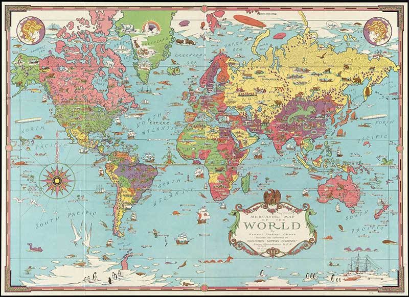
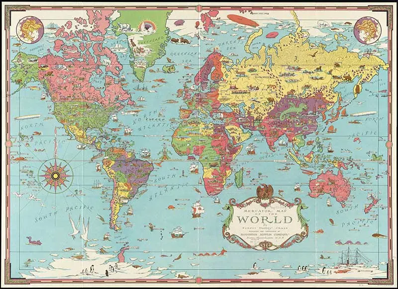
4. Mercator Map of the World
A stunning colorful pictorial map of the world. There are numerous illustrations of animals, people, ships, sea monsters, wind heads, and geographic features, such as mountains, parks, lakes, etc. I especially love all the penguins in Antarctica.
You can find many more vintage world maps here. (This map was used for the DIY tea light lanterns craft)
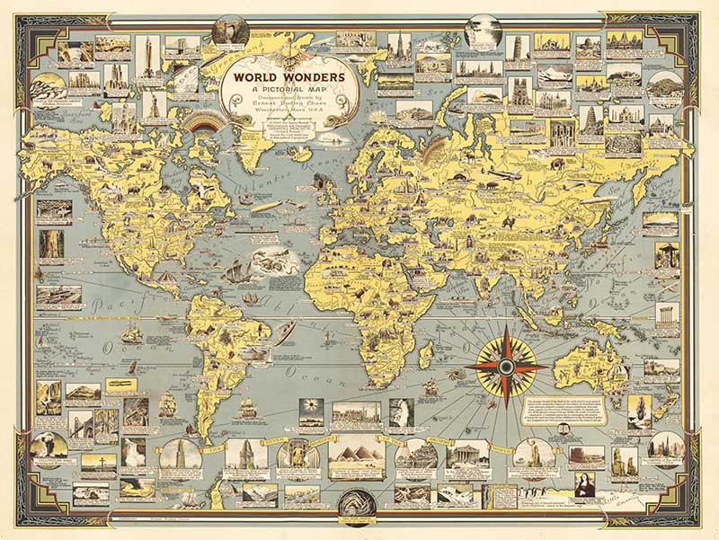
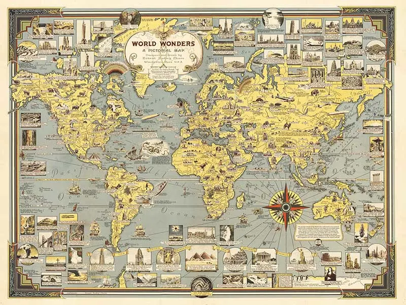
5. World Wonders, A Pictorial Map
Published in 1939, this Ernest Dudley Chase map includes hundreds of images of global landmarks and triumphs of technology (largely related to the nascent field of air travel).
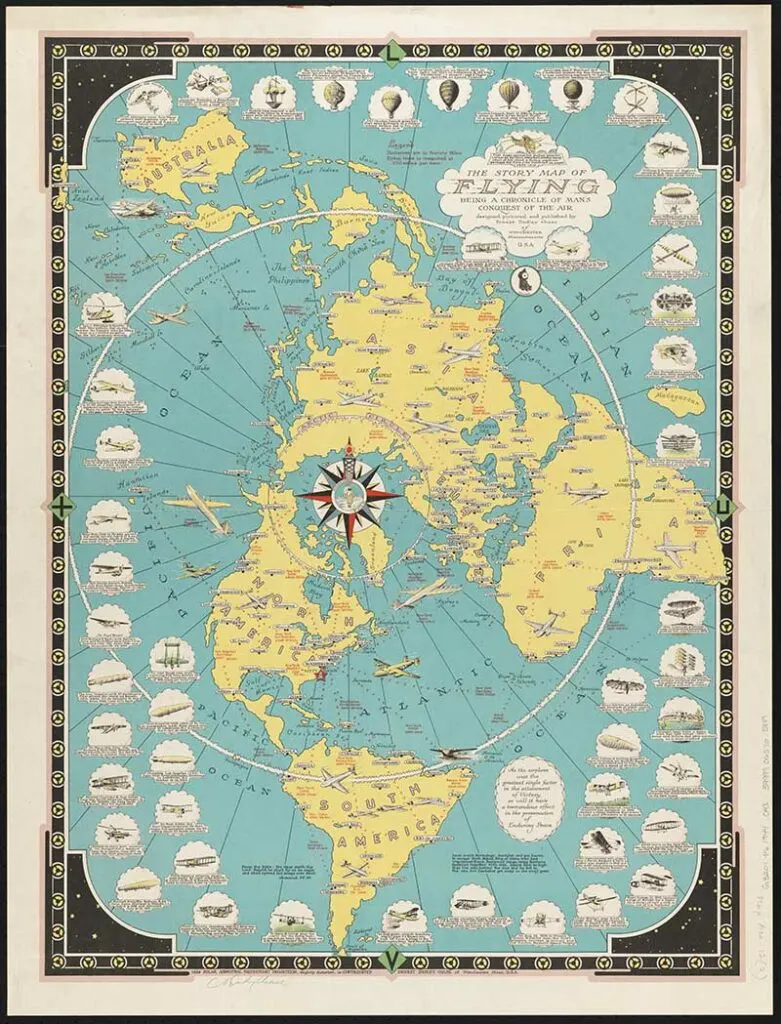
6. The Story Map of Flying
“The story map of flying : Being a chronicle of man’s conquest of the air.” Published in 1942, the map is filled with drawings and images of flying machines with descriptive text.
Unlike Chase’s other maps, this world map is taken from a hemispherical perspective, more specifically from the north pole.
If you like this particular map, then you should check out some of these vintage airline route maps or even these hot air balloon illustrations.

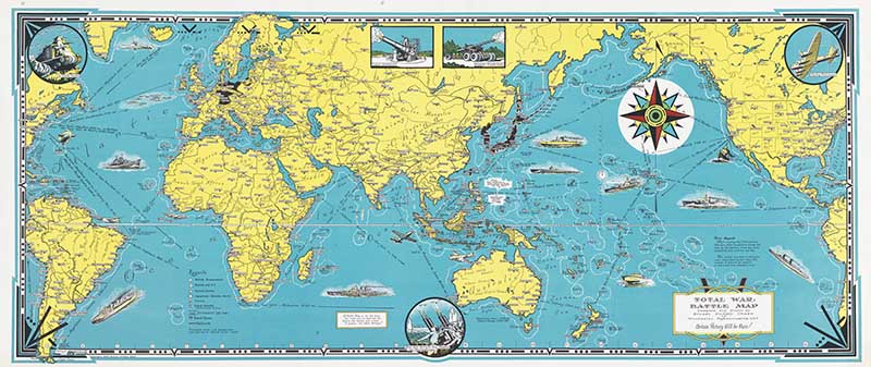
7. Total War Battle Map
Published in 1942 World War II battle map with all countries and major cities throughout the world. Legend and symbols show British possessions, combined British & U.S. possessions, and those of the French, Japanese and Dutch islands.
Legend with symbols: naval bases, railroads, pre-war boundaries. There are five insets of tanks, guns and aircraft and twelve drawings in the oceans of ships and aircraft.

There is a wonderful Japanese pictorial world map with this collection of vintage board game images.
Russia is often featured as an octopus on cartoon maps, there are a couple of those maps in this octopus illustrations collection.
I hope you enjoyed these amazing pictorial world maps. There are many more free vintage maps to explore on the site, you might particularly enjoy the 3D old maps of the San Francisco bay area or these pictorial educational geographical maps or the pictorial river maps of Harold Fisk.
chris
Sunday 20th of November 2022
Thank you i have been really enjoying and learn here amazing collection.
claire
Monday 21st of November 2022
That's lovely to hear; thank you.
Sheri
Monday 18th of October 2021
Thank you so much for sharing your wonderful collection!
claire
Monday 18th of October 2021
Thank you, I'm glad you enjoyed them.
Cecilia
Sunday 22nd of August 2021
What a great collection! Thanks for sharing at Vintage Charm!
claire
Monday 23rd of August 2021
Thank you so much, they are fun.