
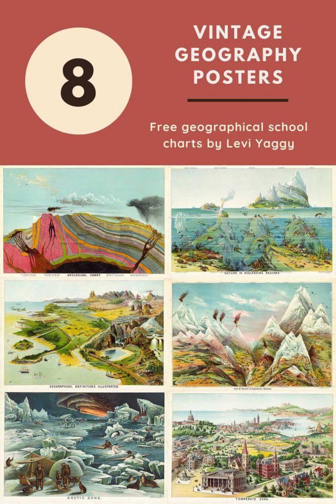
Discover a vibrant collection of free vintage geography charts that work just as beautifully as creative wall art as they do learning tools. Think bold colours, classic maps, and science illustrations perfect for studios, galleries, mood boards, or eclectic home decor.
The stunning geography posters in this collection are all by Levi Yaggy. They are from a group of beautiful geography charts used in schools in the US from 1887.
In the past, I have shared collections of illustrated zoological posters and botanical posters from the Larousse Illustrated dictionaries. This collection of chromolithographic prints focuses on large educational geography posters that were actually used in the classroom.
Yaggy published a teacher’s handbook to accompany these amazing educational charts called, “Teacher’s handbook: designed to accompany Yaggy’s Geographical Study ” which can be downloaded here.
There is also a collection of French Natural History classroom posters on Pictureboxblue by Emile Deyrolle.

The Vintage Chromoligraphic Educational Charts
Chromolithography is a unique method for making multi-colour prints. It was a successful method of colour printing using chemicals developed in the 19th Century. Chromolithography was a highly skilled art, and prints could take weeks or even months to produce.
The print technique produced excellent, colourful, vibrant results, evident in Yaggy’s large geographical charts. They are some of the most beautiful old-school charts I have come across.
I know they were initially for educational purposes. Still, the colours and artwork in these vintage geography posters are so beautiful that they would look fabulous framed and hung as home decor. Who knew geography could look so beautiful?
Luckily, these geography charts are relatively large; the images are the original size of about 86cm (3ft) in width at 300dpi. To download the larger picture, click on the title above the print you want, and it should open in a new tab in your browser.
If you right-click the large picture, you should see the “save as” option, which lets you save the image to your device.
As the original images are so large, I recommend sending the files to your local print shop or an online print shop to print the poster on quality paper.
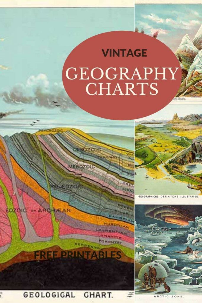
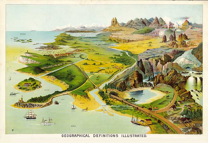
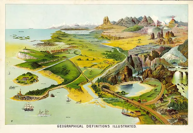
1. Geographical Definitions Illustrated
This fine color chromolithograph educational geography poster is an illustrated definition of geographical terms.
From the definitions of many different natural landscape features and coastal definitions to urban and man-made geographical features.
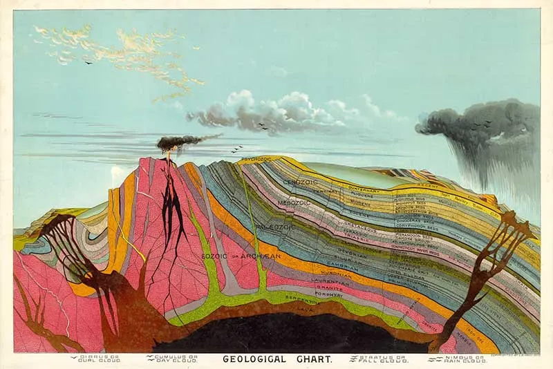
2. Geological Chart
A vintage educational poster of a geological model of the Earth’s core and surface, including an illustration of a volcano.
The layers of the Earth’s core are named and labelled, as are the different types of clouds in the sky.
I love the vibrant colours of this geology chart; it makes the Earth’s crust look like a rainbow and a piece of artwork.

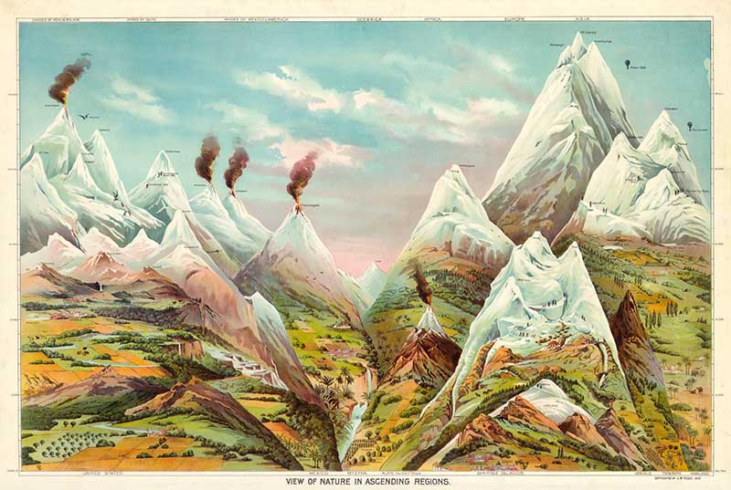
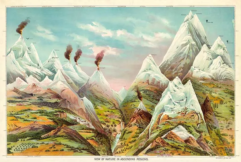
3. View of Nature in Ascending Order – Geography Chart
An educational geography poster illustrating the world’s mountains and volcanoes.
The major mountains are shown for each continent (except Antarctica). The chart includes other exciting details, such as when certain 19th-century explorers climbed the mountains.
Major Mountain Cities are also named, including Denver, Leadville, Animas Forks, Mexico City, Toluca, St. Bernhard, St. Gothard, Birmingham, London, Chambury, Cashmere, Darjeeling, Dangoutre and Pamachun.
The chart interestingly also shows the major crops grown by region.
If you are interested in mountain sketches and mountain charts there are several more on Picutreboxblue.
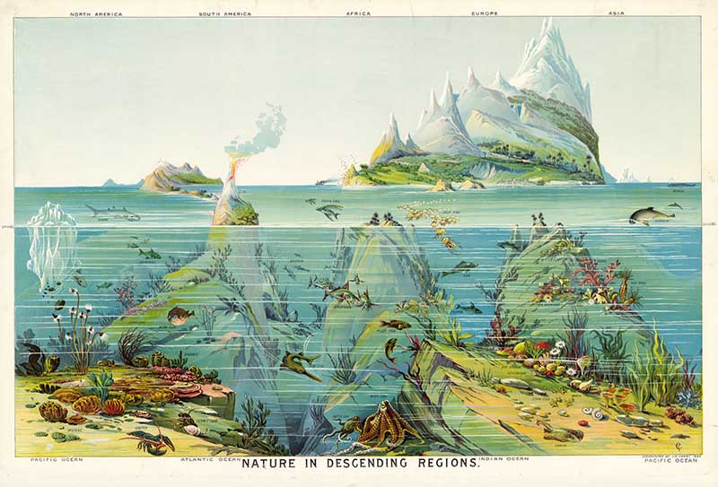
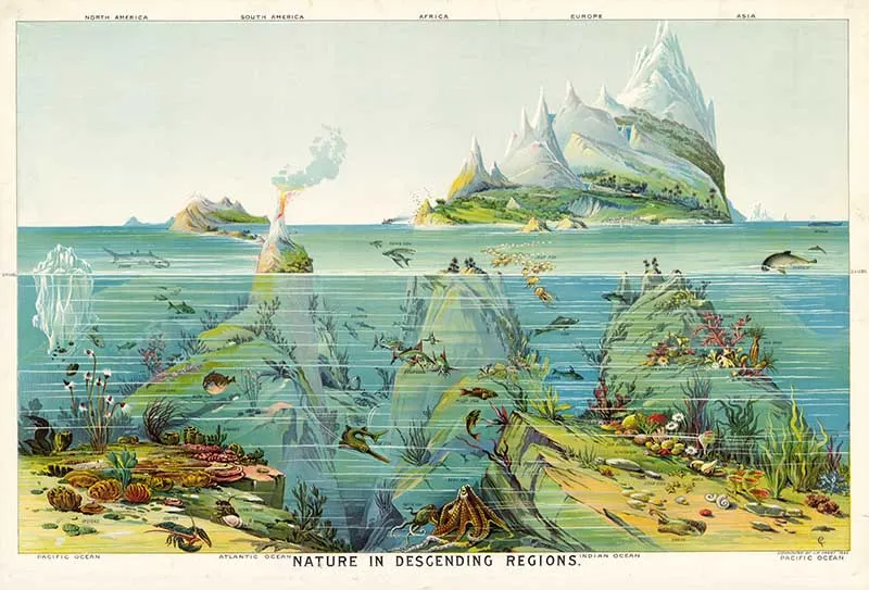
4. View of Nature in Descending Order – Geography Chart
A fine colour print focusing on the sea life of the Pacific Ocean, Atlantic Ocean and the Indian Ocean.
For more colourful natural history sealife posters, try the Adolphe Millot collection. And check out these vintage nautical illustrations.
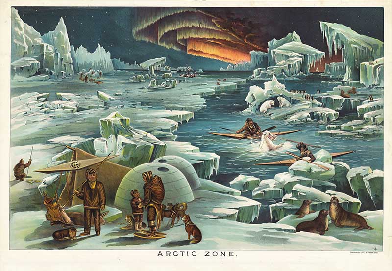
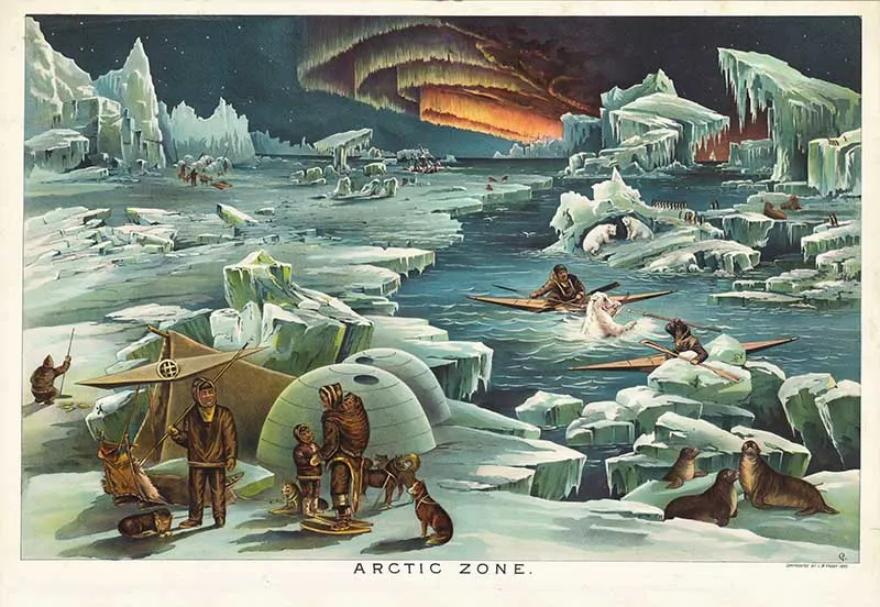
5. Geography Print – Arctic Zone
Yaggy’s geographical illustration of the Arctic Zone. The poster depicts a domestic igloo scene, with Eskimos in kayaks hunting a polar bear, penguins, and sea lions.
Interestingly, this geographical poster features both penguins and polar bears. However, the two species would never meet in real life except in zoos, as polar bears are confined to the Northern Hemisphere and the Arctic. At the same time, penguins are only found in the Southern Hemisphere and the Antarctic regions.
The picture also depicts a wonderful illustrated scene of the Northern Lights.
There are many vintage maps of the North Pole to download for free on Pictureboxblue.
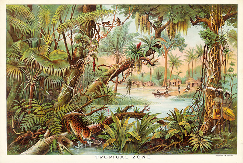
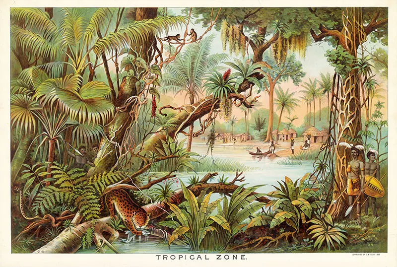
6. Tropical Zone
Yaggy’s geographical posters of the tropical zone. The picture depicts a jungle scene with animals.
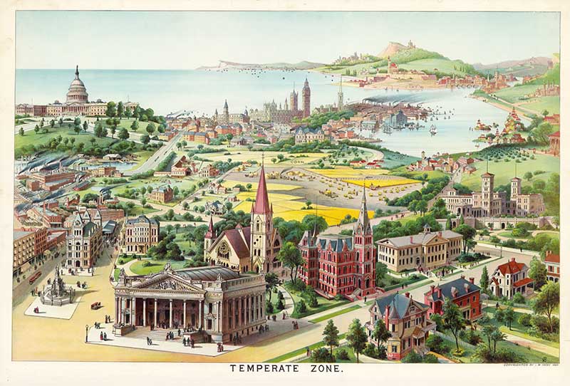
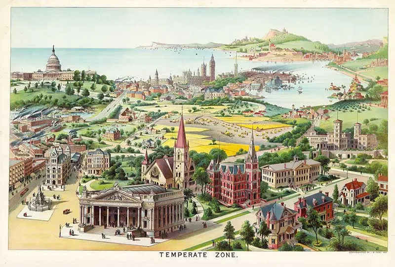
7. Temperate Zone
This geography poster of Yaggy depicts modern civilisation at the time. The poster contains famous buildings worldwide, from Big Ben and the Houses of Parliament to Chinese temples. There are many churches, cathedrals, and factories illustrated as well.
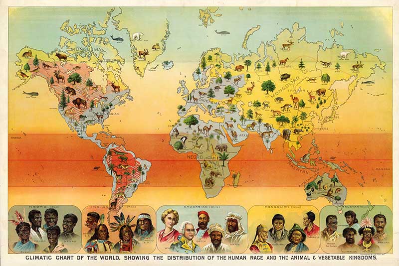
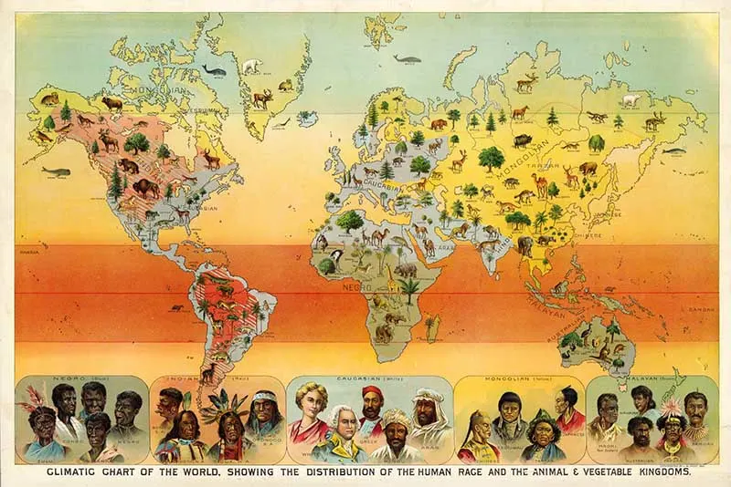
8. Geographical Climatic Chart
A pleasing colour world map, with fascinating (and very 19th Century Anglocentric) images of humans along the bottom of the map.
The world chart is peppered with mammal illustrations for each continent. These illustrations look very similar to those of Adolphe Millot’s animal posters.
There are many collections of world maps on Pictureboxblue.
Other Related Collections
There are some Yaggy planetary posters in the astronomical poster collection on Picture Box Blue.
If you loved these posters, you will love the beautiful geographical maps of the Mississippi River by Harold Fisk, these vintage mineralogy charts, and the amazing educational pictorial maps of Ernest Dudley Chase.
If you enjoyed these geographical posters, don’t forget to check out the huge collection of free maps to download on Pictureboxblue.com.
There are also many more free old educational posters to print here, including these amazing Victorian Science Posters and astronomy prints by John Emslie.

Harjith
Monday 8th of April 2024
Simply amazing. I would love to make these maps in school. Reminds me of those great days
claire
Tuesday 9th of April 2024
Yes they are lovely colourful detailed maps.
Anne
Monday 28th of September 2020
Thankyou so much for making these pictures available in such an easy to use format. I am printing them out in miniature to make books for my Museum of Curiosity room box that I have just made a start on.
Harjith
Monday 8th of April 2024
@Anne,
That seems like a great project
claire
Monday 28th of September 2020
Thank you, that sounds like a really fun project.
Kindra
Thursday 27th of August 2020
Do you have any dinosaur charts/posters? I love these vintage posters but can not seem to find anything that shows different dinosaurs all in one image.
Thanks.
claire
Sunday 30th of August 2020
Hi Kindra, sorry I don't at the moment but I am on the lookout for some and will post them as soon as I find them.
Julie
Sunday 12th of July 2020
When you shared this at Handmade Monday the text came up as 'amazing old school poster'. Is it embarrassing to admit that I was expecting something just a bit old fashioned (ie old school) rather than actual educational posters?!! Doh! They are fab, and will be one of the features later today :-)
claire
Tuesday 14th of July 2020
Thank you, Julie. I look forward to seeing the feature. Yes, they are amazing these old posters.