
Unique Vintage Maps of United States to Download
I’ve curated a lovely and unusual collection of vintage maps of the United States of America. All the maps are copyright free so you can download them and do what you want with them. Whether that is to hang a map gallery wall or decorate furniture with them like with this map desk.
I’ve only been to the USA three times and that’s been over the last 21 years. The first time was visiting my boyfriend (now husband) who was working in Atlanta for a short while. The second was accompanying the same boyfriend on a course in Tampa. The third time was for a wedding at the top of the Empire State (no not mine).
What I do know is that I will be visiting again one day. There is so much to see. The USA is only slightly smaller than the whole of continental Europe. Like Europe the climate, geography and terrain is just as varied. So I know there is so much more to explore and see.

The PDF downloaded maps of the United States will be of a higher resolution then the images below.
To download the map that you want, click on the title above that map. A higher resolution of the map will open in a new window in your browser. Click on the higher resolution map with your mouse and you will have the option to save the map to your hard drive.
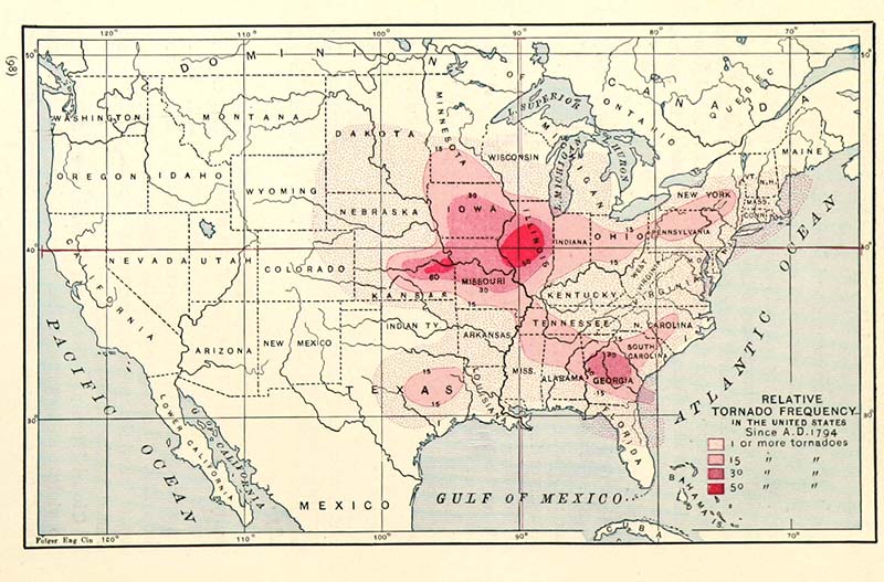
1. Tornado Map of The USA Since 1794
This map is from the textbook “Eclectic Physical Geography” by Russell Hinman and published in 1888. This unusual old map of the United States, shows the frequency of Tornadoes in the USA since 1794. As you can see from the map Illinois and Kansas are the tornado hot spots!

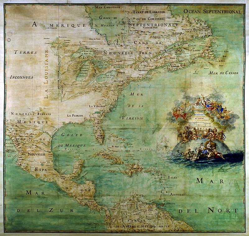
2. Very Old Map of United States 1681
A French Map of North America by Claude Bernou dated 1681. According to the Library of Congress “The map shows many of the discoveries from French expeditions in the Mississippi Valley from 1672 to 1681 and indicates the position of three forts constructed in 1679 and 1680: Fort Conty (near Niagara Falls), Fort Miami (south of Lake Michigan), and Fort Crèvecoeur (on the left bank of the Illinois River). In this representation, the Mississippi River ends at its confluence with the Ohio River. “

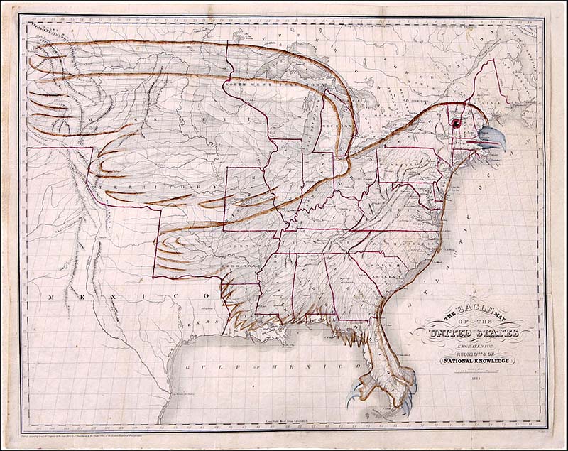
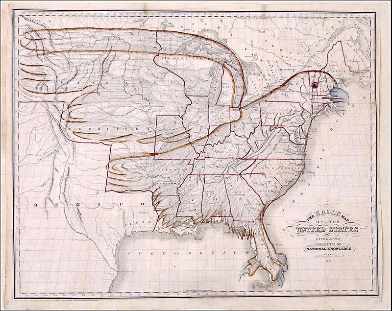
3. Eagle Vintage Map of The U.S.A 1833
This unusual but fabulous Eagle Map of the United States is a teaching wall map from the book “Rudiments of National Knowledge, Presented to the Youth of the United States, and to Enquiring Foreigners. By a Citizen of Pennsylvania” by E.L. Carey & A. Hart. Dated 1833.
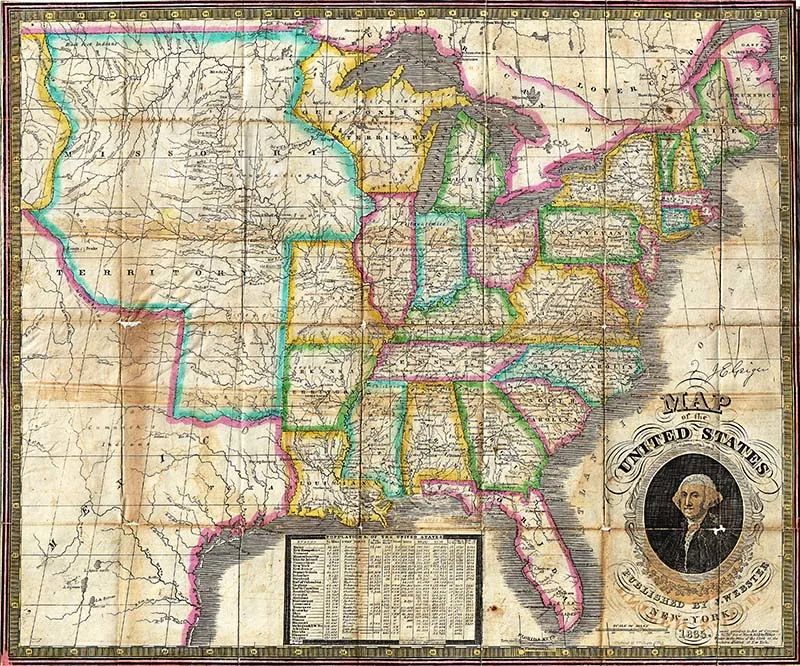
4. James Webster’s Map of The USA (1835)
James Webster’s rare map of the United States (1835). Extends from the east coast of the United States westward as far as the Rocky Mountains, including much of Texas.
It also has a charming portrait of George Washington in the bottom right-hand corner. This is a large map. The chart at the bottom center of the map shows the population of major cities and each state.

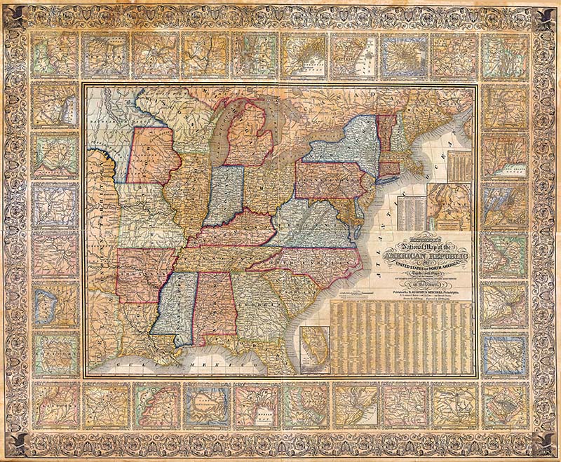
5. 1845 Mitchell’s National Map Of The American Republic
This wall map of Mitchell’s is considered to be a significant example 19th century American cartography. The map has historical significance as it shows the rapidly changing national and domestic political borders of the time.
The border of the map is surrounded by city maps and the chart in the bottom left contains population statistics for every county in each state or territory. Dated and copyrighted 1845.
Again this being a wall map and not from a book it is very large. Great for hanging on a wall.
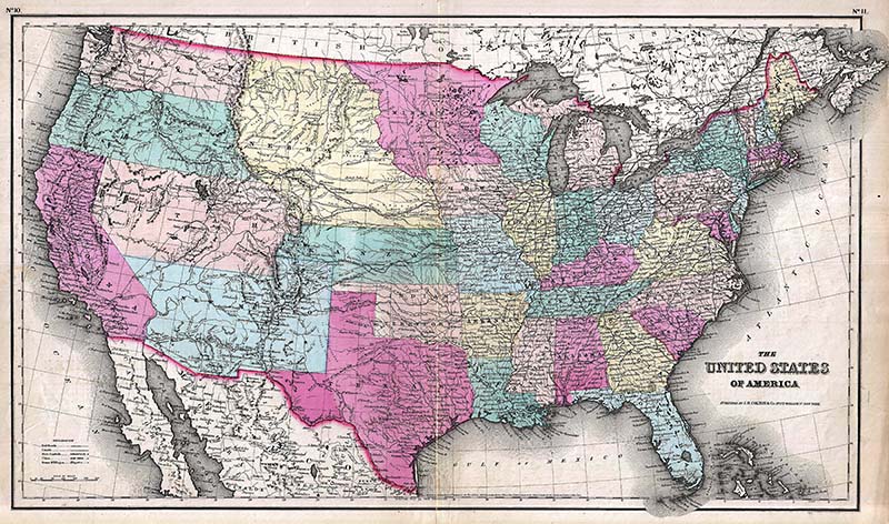
6. Colton’s 1857 Vintage Map Of The United States Of America
A beautiful map with the states in different colors. The Map has been hand-colored in pink, green, yellow, and blue pastels to define state and territorial boundaries. Surrounded by a simple line border.
The map is from George Washington Colton’s 1857 Atlas of the

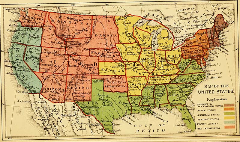
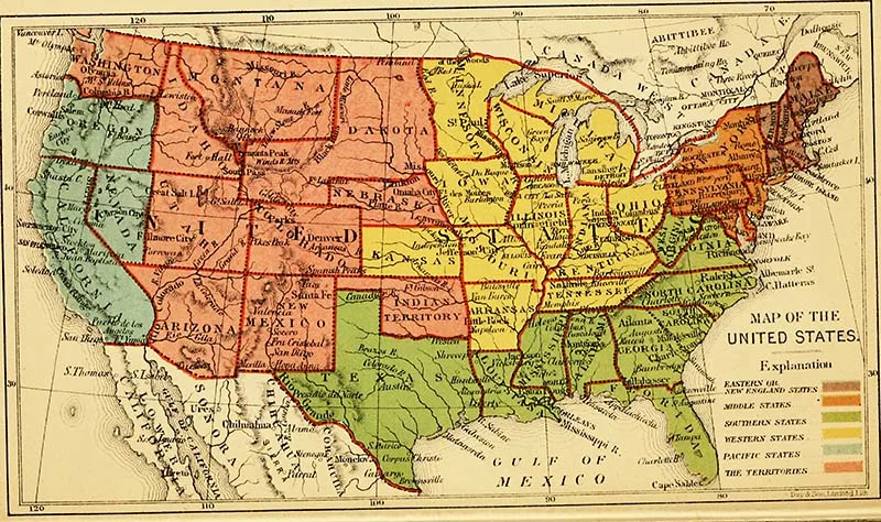
7. 1866 Bacon’s Map Of The USA
One of my favorite vintage maps of the United States, this map is from the 1866 “Descriptive Handbook of America”. There are 37 states divided into color-coded groups. These are, Eastern, Middle, Southern, Western and Pacific.
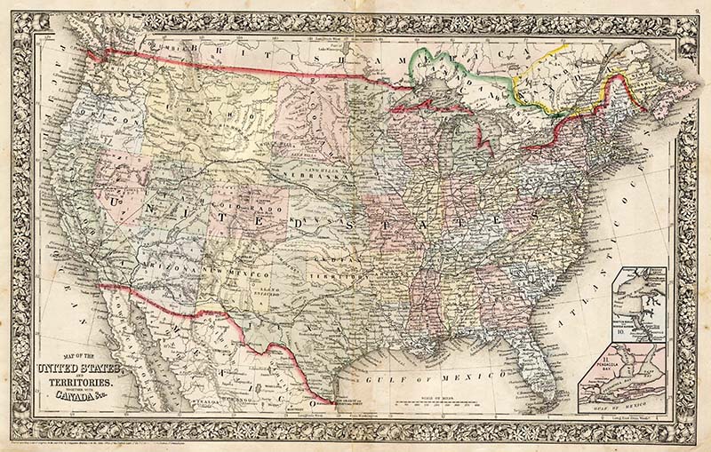
8. Mitchell’s 1864 Map of the United States
Another lovely example from this collection of vintage maps of the United States. The map shows the transport routes such as the railroads and mail routes in great detail.
The states are in lovely pastel colors and the whole map has an attractive floral border.

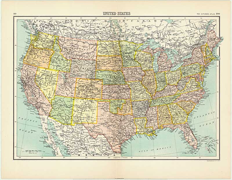
9. Bartholomew’s Map Of The USA 1898
I have personally scanned this map from my own collection. This particular map is from Bartholomew’s ” Citizen’s Atlas of the World ” published in 1898.
Bartholomew’s atlas is actually considered to be the most popular atlas ever published. So maybe this map out of all the vintage maps of the United States could be considered the most popular!

If you liked these vintage maps of the USA then you may also want to check out some of my other USA map posts. I have maps of the Southern United States and vintage maps of New York. There is also a stunning collection of vintage birds-eye-view maps of San Francisco Bay and a vintage USA game board illustration.
There are also some US airline route maps in this vintage airline poster collection.
If you are interested in the natural history of American check out these stunning Mark Catesby prints.
There are some stunning maps of the Mississippi River here that look like pieces of art.
Other maps to check out:
25 Trending Antiques to Sell that are in High Demand – Ecommerce News Hubb
Tuesday 7th of March 2023
[…] Tornado Map of The USA Since 1794. Image source. […]
Carol
Thursday 21st of January 2021
Am I missing something? Where do you get the free download?
claire
Saturday 23rd of January 2021
If you click on the title above the map that you want, a higher resolution of the map will open as a new window on your browser. If you then click on the map you will have the menu option to save it to your hard drive, saving it is the same as downloading. I hope that helps 😊
Catherine Grenga
Saturday 17th of August 2019
I LOVE that you have collected all of these treasures in one place! There are so many that I would like to print! Do you have a recommendation on how to print them and get the best results? What type of file to use, how large I can print it, where to print it, and what type of paper? Hopefully without breaking the bank:) Thanks!
claire
Sunday 18th of August 2019
If you want to print a map for a wall I suggest you use an online print shop and print it as a poster. Many online printers have their own software which will determine the size to print. If you click on the title above the map you want the image will be of a higher resolution then the one on the page.
Cecilia
Saturday 16th of March 2019
Thanks for sharing these beautiful maps at Vintage Charm!
claire
Sunday 17th of March 2019
Thank you,I’m pleased you like them.
Chloe Crabtree
Saturday 16th of March 2019
These are fascinating. I have enjoyed looking at them in detail. My grandmother was born in Okalahoma before it was a state, truly works of art and history! Thank you for sharing at Celebrate Your Story!
claire
Sunday 17th of March 2019
Thank you, that’s interesting. I love looking at the history in old maps.